Help Center
We're here to help.
-
Common FAQs
-
What are features of this platform?
Earthbook, name of this website, is a 4D platform operated through browsers. You can upload and display UAV’s aerial photos, 3D models then share to others through earthbook’s APIs.
-
What functions are provided in earthbook?
It provides:
1. post wall- It lists yours and others public work.
2. data warehouse- You can choose multi type data from the warehouse and show it on 3D map.
3. release post- You can release your work on post wall.
4. studio- It provides screenshot, screen recording and multi time-stage images comparison
5. measure- It provides distance and area calculators.
6. plot- You can add line, circle, rectangle, polygon and POI on 3D map
7. basic setting- You can adjust base map, digital terrain model, vertical exaggeration, fog, coordination system and display features here.
8. upload- You can upload your aerial photos, orthographs and 3D models to your cloud space. -
Does this platform need GIS background?
You don’t need GIS background to use earthbook. It provides a place to show uav’s work. Moreover, you can visit others work through post wall to enhance your skills.
-
How to contact if I have problems about earthbook?
You can contact us by email (service@earthbook.xyz),
call (03-6578062) or fax (03-6577225).
We appreciate your feedbacks.
-
Sign Up
-
Is it free for registration?
Yes, there is no extra fee for becoming a member. However, you can pay for enlarging cloud space and some special functions.
-
Where I can register?
In home page, you can choose Facebook account or Google account to login. You can fill your email address, name and password to register alternatively.
-
Functions
-
Basic Setting
There are some functions can be adjusted in setting tab, including base map, 3D terrain, coordination system and so on. In base map function, there are several types of images you can choose like satellite images or street maps. In 3D terrain function, there are three different resolution models can be selected, ellipsoid, Cesium world terrain and Taiwan 20m DTM provided by MOI. You can adjust vertical exaggeration by selected last two DTMs. This platform also provides some effects to help you generate a vivid earth like coordinate grid, sun lighting, terrain, water ripple and cloud. Showing metadata of *.shp file is possible, if you turn on the” Layer information” function.
-
Data Warehouse
Users can choose interested files to be imbedded on the map as an integration data, including 3D models, 2D layers and user’s photos or videos took by UAV. 2D layers took in same area but at different time can be compared as a time-lapse GIF picture (for more than two photos) or a swipeable screen (for two photos), which is shown in studio function.
-
Release Post
Users can release integration data and description for it on the post wall. Privacy level for posts can be set as public, privacy or shared between cooperation. In the post, we provide several ways to share it including direct web address, posted to facebook and imbedded-available iframe code to website.
-
Studio
Users can print screen or take short video to demonstrate an integration data. Moreover, time-lapse GIF picture (for more than two photos) or a swipeable screen result (for two photos) can be generated when users select them in data warehouse function.
-
Measurement tools
We provide basic measurement tools for users including ruler and area calculator.
-
Plot
Users can plot points, lines and polygons on the map, which are adjustable with their color, transparency, locations and can be added with hyperlinks or pictures. These make maps are easier to read.
-
Flying Missions
-
File Upload Considerations
Video:The supported file formats are .mp4 and .mov.( SRT is required )
Flight path:Accept only csv file
CSV Example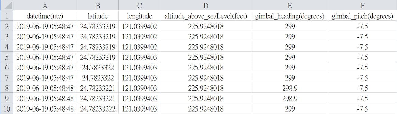 * Csv file can be generated via AirData
(requires FlightRecord_xxx.txt)
Field names must be the same
* Csv file can be generated via AirData
(requires FlightRecord_xxx.txt)
Field names must be the same
                                - datetime(utc)
                                    * y-m-d h:i:s
                                - latitude
                                - longitude
                                - altitude(feet) or altitude_above_seaLevel(feet)
                                    * Elevation (Above Sea Level)
                                - gimbal_heading(degrees)
                                - gimbal_pitch(degrees)
-
My Files
-
Layers - File Upload Considerations
The supported file formats are:shapefile, .tif, .tiff, .gif, .jpg, .png, .kml, .czml and .geojson.
* shapefile(mandatory files):.shp, .shx and .dbf
* shapefile(optional files):.prj, .sbn, .sbx, .fbn, .fbx, .ain, .aih, .ixs, .mxs, .atx, .shp.xml, .cpg and .qix
* notice:all the files in a shapefile must have the same name and upload at the same time. -
3D model
Refer to the following example structure, you can choose to upload as ZIP or upload the entire folder directly
Please place all files in the root directory or the first level folder
Example Structure:uploaded_model - model.xxx ...Example Structure:uploaded_model - model/ - model.xxx ...Wrong Structure:uploaded_model - model/ - model/ - model.xxx ...earthbook supports the following types of 3D models:
Wavefont OBJWavefont OBJ is a 3D model file format. Due to its open file format and simple structure, it is currently widely used by 3D applications.
Example ZIP Structure:
When uploading the model, please compress .obj, .mtl (material description file) and material image in a ZIP file and upload.
Note: Please name all files in the ZIP file in English to avoid garbled characters
                            uploaded_model.zip
                              - model.obj
                              - model.mtl
                              - textures/
                                - tex01.jpg
                                - tex02.jpg
Please modify the original mtl file according to the placement location of the texture file. If the above file structure is used as an example, the texture reading path is adjusted as follows:
Example mtl File:newmtl metrail_0 Ka 0.200000 0.200000 0.200000 Kd 1.000000 1.000000 1.000000 Ks 1.000000 1.000000 1.000000 Tr 1.000000 illum 2 Ns 0.000000 map_Kd ./textures/tex01.jpgSample file downloadAltizure ModelAltizure provides high-quality online 3D reconstruction services. Users upload image files and generate model files after reconstruction (OBJ files are packaged in ZIP format) for users to download.
Example ZIP Structure:
earthbook supports loading model files produced by Altizure. Before uploading, please make sure that the parameter file config.json and all model files are located in the root directory of the ZIP archive.uploaded_model.zip - config.json - tile_0_0_0_tex.mtl - tile_0_0_0_tex.obj - tile_0_0_0_tex_tex0.jpg - tile_1_0_0_tex.obj ...Sample file downloadCesium 3D Tiles3D Tiles is an open 3D model file standard, which is developed and maintained by the Cesium team. 3D Tiles have good streaming efficiency in network applications and are suitable as model files in network applications.
Example ZIP Structure:
When uploading, please package the 3D Tiles file as a ZIP. By default, the system will find tileset.json in the root directory as the model starting file.uploaded_model.zip - tileset.json - part_1.b3dm - part_2.b3dm - part_3.b3dm ...Sample file downloadGLB/GLTFglTF (derivative short form of Graphics Language Transmission Format or GL Transmission Format) is a standard file format for three-dimensional scenes and models. The GLB file format is a binary form of glTF that includes textures instead of referencing them as external images.
Example ZIP Structure:
You can choose whether to keep the animation when uploadinguploaded_model.zip - model.glb ...Sample file download(GLTF) Sample file download(GLB)DAECOLLADA defines an open standard XML schema for exchanging digital assets among various graphics software applications that might otherwise store their assets in incompatible file formats. COLLADA documents that describe digital assets are XML files, usually identified with a .dae (digital asset exchange) filename extension.
Example ZIP Structure:uploaded_model.zip - model.dae - texture_01.png - texture_02.png ...Sample file downloadFBXFBX originated as a replacement file format for Canadian company Kaydara's Filmbox, a software for recording data from motion capture devices. Prior to 1996, Filmbox 1.0 used a file format called FLM.
Example ZIP Structure:uploaded_model.zip - model.fbx ...Sample file downloadContextCaptureExport 3D model via ContextCapture
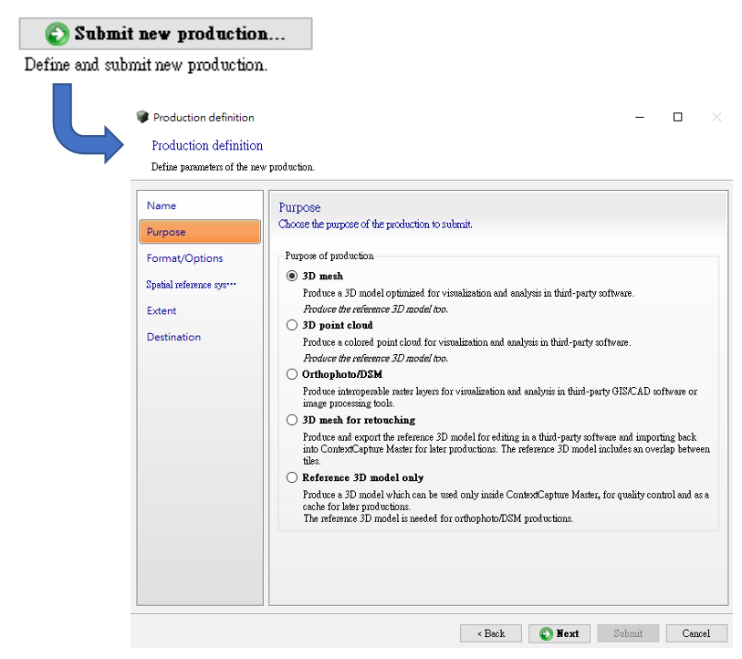
Select the type of model you want to export. The supported formats are:
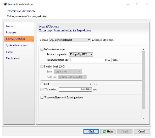
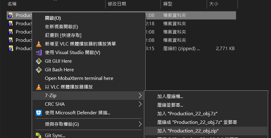
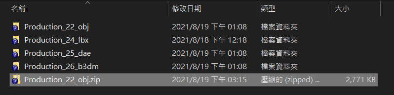
Please select the format you want to upload and pack it into ZIP or directly drag the entire folder to upload.
Example: OBJ path -> D:\{{Project name}}\Productions\Production_22_obj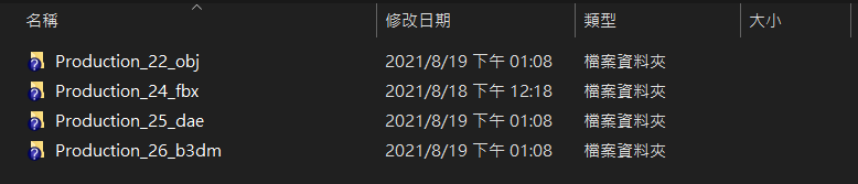
Choose ZIP to upload, please right click and upload it.
 Sample file download(Wavefont OBJ) Sample file download(Cesium 3D Tiles)
Tiling
Sample file download(Wavefont OBJ) Sample file download(Cesium 3D Tiles)No tiling
-
QGIS Plugin
-
How to install?
You can run the installation file directly or install it through a URL.
-
Installation tutorial by installation file
*Please making sure default installed path of QGIS plugin is C:\Users\user name\.qgis2\python\plugins for QGIS v2.x and C:\Users\user name\AppData\Roaming\QGIS\QGIS3\profiles\default\python\plugins for QGIS 3.x
For QGIS versions newer than 3.0::
For windows, please downloading earthbookTool_windows_v3.bat and double clicks on it to execute installation;
or Linux, please downloading earthbookTool_linux_v3.bat and type ./*.bat in the terminal to execute installation.
For QGIS versions older than 3.0 but the oldest version is only supported to 2.04::
For windows, please downloading earthbookTool_windows_v2.bat and double clicks on it to execute installation;
or Linux, please downloading earthbookTool_linux_v2.bat and type ./*.bat in the terminal to execute installation.
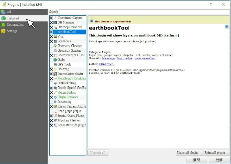
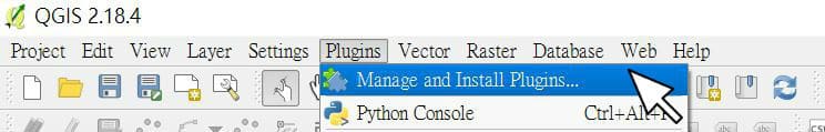
After the plugin installation, executing QGIS then clicking plugins tab>Manage and Install Plugins, you can search earthbookTool and click checkbox for it.
(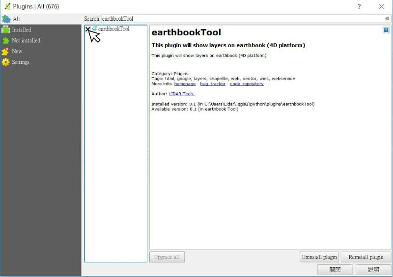
The installation is complete.
-
Installation tutorial through a URL:
Executing QGIS then clicking "plugins tab">"Manage and Install Plugins..."
Clicking "Settings">"Add..."
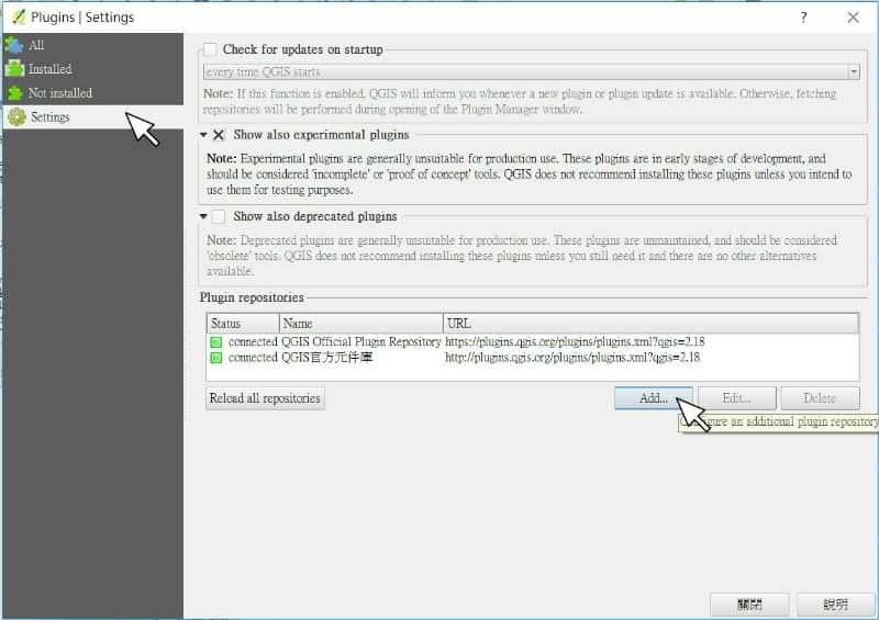
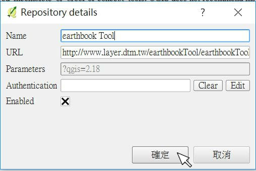
In Repository details, inputting earthbook Tool for name and URL
=> Name : "earthbook Tool"
=> URL : "https://layer.earthbook.xyz/storage/earthbookTool/earthbookTool.xml"
(For QGIS versions newer than 3.0: https://layer.earthbook.xyz/storage/earthbookTool/earthbookTool_v3.xml)
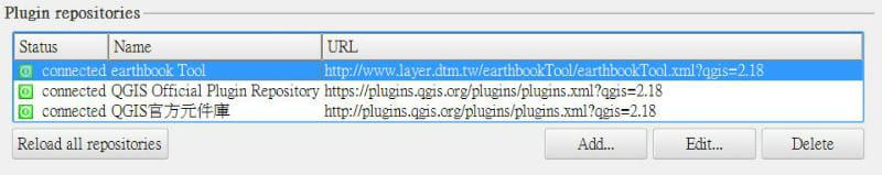
You can search and see the plugin of earthbookTool represented in Plugins>All>Not install
Clicking "earthbook Tool">"Install plugin"
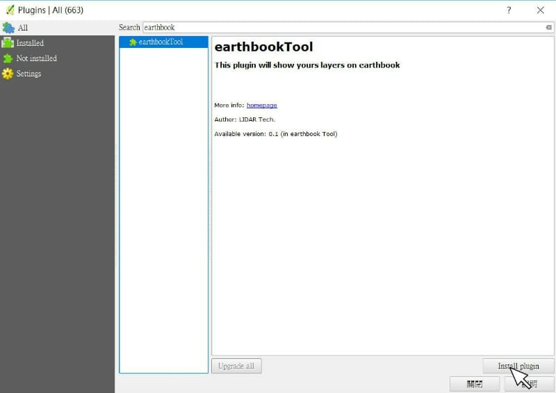
The installation is complete.